The GeoTIFF format has several benefits over the legacy Landscape (.LCP) File,
There are two methods for converting a Landscape (.LCP) File to the GeoTIFF format.
A loaded ♦ New Analysis Area or ♦ Entire Landscape (Default)) item can be saved in a GeoTIFF (.TIF) format file by right-clicking the item and selecting the Create Landscape command from the shortcut menu. The command opens a "Select Destination File" dialog box allowing the user to navigate to the location they want to store the newly created GeoTIFF File. The user must designate Save as Type: as GeoTIFF files(*.tif).
A valid Projection (.PRJ) File, with the same name as the Landscape (.LCP) File, must be in the same folder as the loaded Landscape (.LCP) File. Otherwise use the following Convert LCP to GeoTIFF utility.
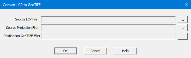
If the Landscape (.LCP) File is not loaded or the Projection (.PRJ) File does not have the correct name/folder select Utilities > Convert LCP to GeoTIFF from the Menu Bar. This will open the "Convert LCP to GeoTIFF" dialog, the user will need to supply the Source LCP File, Source Projection File, and Destination GeoTIFF File.
Click ![]() to the right of the
Source LCP File text box to display
an "Select Source LCP File" dialog. Navigate to the appropriate
folder, select the desired Landscape (.LCP) File and click Open.
to the right of the
Source LCP File text box to display
an "Select Source LCP File" dialog. Navigate to the appropriate
folder, select the desired Landscape (.LCP) File and click Open.
If no projection file is available in the same location as the Source LCP File the following error dialog will appear.
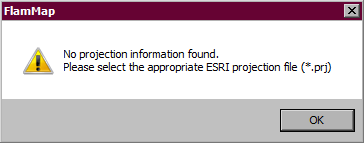
Click OK in the error message box
will close it. Load a Projection
(.PRJ) File by clicking the ![]() button
to display a “Select Source Projection File” dialog box. Navigate to the
correct projection file; make sure the file name is displayed in the File Name text box and click Open.
button
to display a “Select Source Projection File” dialog box. Navigate to the
correct projection file; make sure the file name is displayed in the File Name text box and click Open.
Select the Destination GeoTIFF File
location by clicking ![]() and name
the new file, then click Save.
and name
the new file, then click Save.
Finally click OK on the "Convert LCP to GeoTIFF" dialog to finish the conversion.
This option has the flexibility of being able to navigate to a different location for the projection file if it is not located in the same directory as the Landscape (.LCP) File.
NOTE: Navigating to and selecting a Projection (.PRJ) File is not the same as reprojecting (transforming a dataset from one projection to another) this must occur outside FlamMap in a GIS system. The selected Projection (.PRJ) File MUST represent the map datum and coordinate system of the Source LCP File.