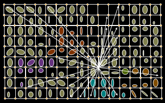
Minimum Travel Time (MTT) is a two-dimensional fire growth model used in FlamMap for TOM, burn probabilities, and perimeter growth. It is also used in WFDSS for Short Term Fire Behavior and FSPro, and in the large fire simulator FSim.
calculates fire growth and behavior by searching for the set of pathways with minimum fire spread times from point, line or polygon ignition sources (Finney, 2002). In theory, the results are identical to wave-front expansion used in FARSITE with the exception that all weather and fuel moisture conditions are held constant over time with MTT but allowed to vary with time in FARSITE.
At a user specified resolution of data cells, the algorithm finds the minimum travel paths by calculating travel times from each node (cell corners) to every other node on the landscape. Travel pathways are straight lines that connect nodes and intersect cells to form segments for which fire behavior is calculated from the input data.

Efficiencies in computation are afforded by stopping the search for a particular node after a specified number of failures occur in the search (in the X- and Y- directions). The algorithm is parallelized to make use of multiple CPUs on a computer system.
In addition to calculating fire growth for a single fire, MTT can be used to compute conditional burn probabilities from a large number of simulated fires from a specified number of randomly located ignition points. These conditional burn probabilities include several assumptions.
Burn probabilities provide one method of evaluating the effectiveness of fuel treatments that removes the uncertainty of ignition sources. A large sample size of ignitions (say 1000’s or 10,000’s) on the treated and pre-treatment landscape gives an indication of the overall effectiveness of the landscape pattern in retarding the growth of large fires. High burn probabilities are related to the sizes of fires that occur on a given landscape -- for the same conditions, large fires produce higher probabilities than small fires (each burn a larger fraction of the landscape). Since fire size is a function of the gross spread rate and duration of the fire, treatments that reduce the spread rate will lower the burn probability. This feature produces a single output map that contains the fraction of the number of fires that encountered each node (0.0 to 1.0). For further analysis this map can be saved in ASCII grid format to import into a GIS where grid statistics and other procedures can be calculated.
Note: this process is very CPU intensive because it involves simulating fire growth from perhaps thousands of random ignitions. This is best performed on multi-processor computers or when long time periods for computing are acceptable.