
Within the United States, pre-made landscapes in a GeoTIFF (.TIF) format file can be downloaded with landfire.gov services using the Utilities > Get Landscape command. This landscape is composed of all eight themes used for FlamMap and Farsite as well as an optional FCCS theme for SpatialFOFEM runs. It uses a custom local Albers projection that keeps the landscape north orientated. The Utilities > Get Landscape command opens the "Get Landscape" dialog.
The "Get Landscape" dialog has two methods for identifying the bounding box for your project.
To help identify the appropriate bounding box for a project the  button will load a shapefile, such as a fire perimeter, when drawing a rectangle. Point or line features can also be loaded.
The ![]() button will remove all the loaded shapes from the map, but not any bounding box you may have drawn. You can use the Edit Layers map control to modify your bounding box or the trash can map control to delete it.
button will remove all the loaded shapes from the map, but not any bounding box you may have drawn. You can use the Edit Layers map control to modify your bounding box or the trash can map control to delete it.
For the Destination File: text box click  to designate a location and file name for the .ZIP archive to be downloaded.
From the LANDFIRE Version: drop-down list select the desired LandFire version.
From the Resolution (meters): drop-down list select the appropriate output cell resolution for the landscape.
Selecting the Include FCCS Layer check box will add the Fuel Characteristic Classification System (FCCS) theme to the downloaded landscape. The FCCS theme is required for a SpatialFOFEM run.
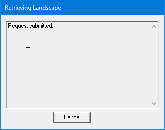
Click  to begin the landscape request and a message dialog indicates the status of the request.
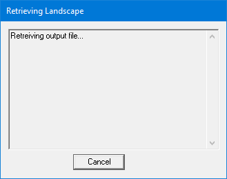
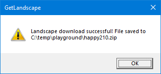
Another message dialog appears when the download is complete, reminding you of it's location.
You will need to extract the .ZIP file to load it into a FlamMap Project using the Landscape > Open Landscape command. Richt click the .ZIP file and click Extract All... on the shortcut menu.

There are three files included in the .ZIP,
|
GeoTIFF Band |
Data Theme |
Units |
Data Type |
|
1 |
Elevation |
Meters |
INT16 |
|
2 |
Slope |
Degrees |
INT16 |
|
3 |
Aspect |
Degrees |
INT16 |
|
4 |
Fire Behavior Fuel Model |
Class (40 FBFM numeric code) |
INT16 |
|
5 |
Canopy Cover |
Percent |
INT16 |
|
6 |
Crown (Stand) Height |
Meters*10 |
INT16 |
|
7 |
Crown Base Height (CBH) |
Meters*10 |
INT16 |
|
8 |
Crown Bulk Density (CBD) |
kg/m3*100 |
INT16 |
|
9 |
Fuel Characteristic Classification System Fuelbeds |
Class (FCCS numeric code) |
INT16 |
More information can be found at landfire.gov.
Some simple map controls are available to help identify a landscape area.
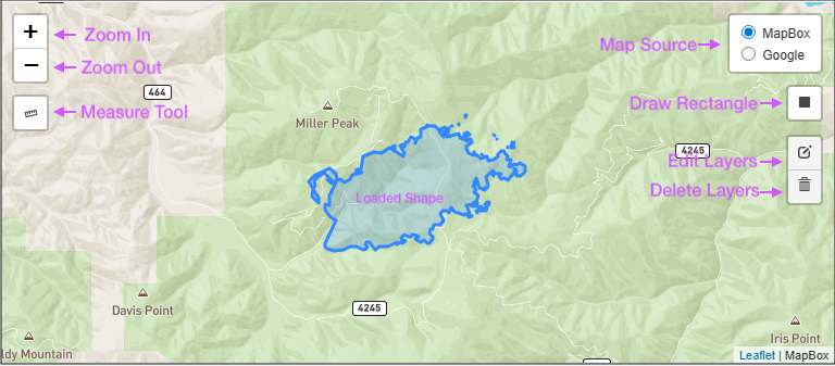
Click the Measure Tool and the cursor changes to a crosshairs. Click on the starting point and move the cursor to your point of interest. Turn off the measure tool by clicking it again.
Use the Draw Rectangle control to draw a bounding box for a landscape download.
Modify a bounding box with the Edit Layer control. This control will only edit the drawn bounding box.
The Delete Layer control will delete any bounding box that's been drawn. Use the ![]() button to remove any shapefiles you have loaded.
button to remove any shapefiles you have loaded.
The  button on the "Get Landscape" dialog opens a list of your previous Get Landscape requests.

Click on a row to select it and use the  button to display the previous request into the "Get Landscape" dialog where you can make the same request or modify it. Or use the
  button to remove the request from your history.