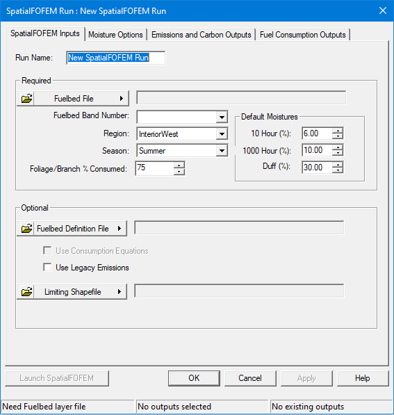
A SpatialFOFEM run begins by identify the FCCS layer and other settings or options. When creating a new SpatialFOFEM run the "SpatialFOFEM Run" dialog with the SpatialFOFEM Inputs tab displayed.

Additional information on FOFEM can be found in the FOFEM Users Guide available at the FOFEM website.
Click the  button and select Open Fuelbed Identifier File. This needs to be a GeoTIFF format file that includes a band with the Fuel Characteristic Classification System (FCCS) codes.
The easiest way to get a FCCS theme is to use the Utilities > Get Landscape tool and include the FCCS theme in your Landscape File. The FCCS theme is also available through the LandFire Data Distribution site. Or for the ambitious, you can make your own. Regardless, the FCCS theme must have the same extent and projection as the Landscape File and be co-registered, with the FCCS theme cells aligned with the landscape cells.
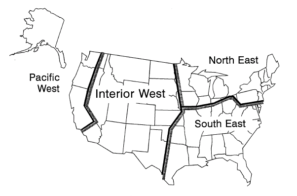
Select the region of your project from the drop-down list.

Select the season of burn from the drop-down list. In some cases, season is used to select consumption equations.
SpatialFOFEM does not predict whether a crown fire will occur and canopy fuels will be consumed. It requires the user to estimate the proportion of the stand affected by crown fire. SpatialFOFEM simply applies this proportion to the canopy foliage and one-half of the canopy 0-1/4 inch branch wood, so that consumption of these fuels is represented for purposes of estimating smoke production or carbon budget.
Set the default fuel moistures for 10 Hour, 1000 hour, and Duff fuels. Entry required even if a geospatial fuel moisture file is supplied. This value will be used when geospatial fuel moisture file values are NODATA.
A default Fuelbed Definition File for the standard FCCS codes (SpatialFOFEM_FCCS.csv) is included in the Flammap6 installation directory. Default fuelbed parameters for standard FCCS codes can be modified or custom codes included in the Fuelbed Layer GeoTIFF file can be parameterized by loading an additional custom Fuelbed Definition File.
To load a custom Fuelbed Definition File click the  button and select Open Fuelbed Definition File.
Fuelbed information in the custom Fuelbed Definition File will override fuelbed information in the default SpatialFOFEM_FCCS.csv file for the FCCS fuelbeds included in the loaded file. Fuelbed information for standard FCCS codes not included in the custom Fuelbed Definition File will be read from SpatialFOFEM_FCCS.csv.
If a custom Fuelbed Definition File is loaded the Use Consumption Equations check box will be available.
SpatialFOFEM uses the Burnup model (Albini and Reinhardt, 1995) to predict consumption of woody fuels.
By default consumption of other fuels (duff, litter, herbaceous fuels, shrubs, and canopy fuels) are predicted using a variety of empirical equations and rules of thumb.
Using a Fuelbed Definiation File allows you to specify different equasions to predict the consumption of other fuels.
Select the Use Consumption Equations check box to direct SpatialFOFEM to use specific consumption equations for six fuelbed components: litter load consumption, duff load consumption, duff depth reduction, mineral soil exposure (MSE), herb load, and shrub load. If this checkbox is not selected SpatialFOFEM will use the default consumption equations.
See the FOFEM User Guide, Scientific Content – Fuel Consumption and Decision Dependency sections for more information.
Legacy Emissions factors are based on an earlier set of factors published by Ward et al. (1993) and are applied to all fuel components. The emissions produced by these equations and methodology have been found to generally under predict emissions, especially PM 2.5 compared to those from Urbanski (2014).
Selecting the Use Legacy Emissions check box will override the current expanded Emission Factors based on Urbanski (2014).
A SpatialFOFEM run can be confined to a portion of the landscape by using a polygon shapefile as a mask. Shapefiles can be single or multi-part polygon files, however the ![]() Statistics CSV text output will not display data for the individual parts, only the totals for a multi-part shapefile. Clicking the
Statistics CSV text output will not display data for the individual parts, only the totals for a multi-part shapefile. Clicking the  button gives the options of loading or clearing a shapefile mask.