The Treatment Optimization Model (TOM) process relies on the Minimum Travel Time (MTT) fire growth method to identify major fire travel routes and attempt to block them efficiently with fuel treatments. For the target weather conditions, this translates to a specific optimization objective to find the specific treatment areas that reduce fire growth rates the greatest for the given treatment amount. In other words, it is attempting to maximize the minimum travel time for fire moving across the landscape. There are a number of assumptions of this analysis that are discussed below.
The explicit objective assumed for landscape fuel management by this analysis is for delayed growth of large or “problem” fires. The reasoning for this assumption follows from the conditions that foster the growth of such fires in areas dominated by suppression-oriented management in western North America. Here, fires become large by escaping initial attack and then spreading far from where they start. Large fires are resistant to suppression efforts because of the dry and windy weather that often fosters their rapid growth, the sheer size and length of perimeter they present to control, and the fire behaviors produced under extreme weather conditions originating their escape (crown fire, spotting). Suppression success typically occurs only when durable changes in the weather abate rapid fire growth. During these periods of active spread, such fires are responsible for the greatest damages to watersheds, ecosystems, and present the greatest threats to human developments beyond the borders of the wildlands per se. Managing the condition of the landscape and the spatial fuel structure, therefore, offers the only possible means to resist the growth of fires under such conditions, reducing the spread rate and ultimate size of the fires. This has been termed a “passive” approach to fire management (Gill and Bradstock 1998) as opposed to fuel breaks (Green 1977, Weatherspoon and Skinner 1996, Agee et al. 2000) that require active fire suppression for benefits to be realized. Fuels are the only element of fire behavior which is manageable, since weather and topography are beyond human control.
By targeting large fires for treatment efforts, the analysis of fire behavior can be restricted to a small subset of weather conditions contributing to large fire growth. Large fires typically occur under the most extreme weather conditions that originate their escape from initial attack. The weather during historic large fires is well known to local fire management officials and can be synthesized from climatological records (Rothermel 1994, Mutch et al. 1994). These weather conditions provide critical data on general fire spread directions and spread rates for all fuel types on the landscape and narrows the focus of fuel management efforts to specific ranges of humidity, fuel moisture, and winds. By assuming a single set of specific weather conditions for large fires (fuel moistures across a landscape, wind speed and direction) fire behavior can be calculated for all areas of each landscape.
Fire behavior for each cell includes fire spread rate components of elliptical fire growth (elliptical dimensions a, b, & c) and the orientation of the major axis of the ellipse (maximum spread direction).
The large size of these fires relative to the size of treatment units also suggests that the starting locations of fires can be ignored, allowing the analysis to focus instead on the directions of fire movement. Large fires moving across landscapes encounter smaller treatment units with relatively wide fronts that have become largely independent of the exact ignition location. The major direction of fire movement is, however, critical because the rapid spread rates of the heading fire (moving with wind and slope) burn the most acreage with the highest intensities (Catchpole et al. 1992). Heading fire is more important to modify than flanking and backing portions of the fire which have lower intensities and cause less severe fire impacts.
The fuel treatment optimization procedure described below depends on fire behavior contrasts between the two fuel profiles for the same landscape extent burning under the target weather conditions: one represents the starting conditions or current state of fuels and forest structure, and the second represents the fuel conditions following treatment. The assumption here is that desired fuel conditions can be identified on a stand-by-stand basis across the landscape for all stands where treatment is possible. These fuel conditions are represented across a large landscape as a rectangular lattice at a fixed resolution. The cells of the lattice are assumed uniform at scales finer than the resolution in terms of fuels, topography, and weather. The treated landscape describes the potential areas for treatment that must total more than the constraint imposed on total area treatable within the planning horizon. Treatment prescriptions within each stand or cell on a landscape, such as prescribed burning or various stand-level thinning guidelines, can vary to reflect local objectives or restrictions on activities. Lands excluded from treatment consideration retain the identical fuel descriptions in both landscapes. Thus, the optimization will choose from the lands where treatments change fire behavior to achieve the greatest collective reduction in landscape fire spread rate.
The optimization algorithm begins by dividing the landscape into a series of parallel strips or regions oriented perpendicular to the wind direction.

The width of these strips is determined as a user input (the Maximum Treatment Dimension) that regulates the maximum size of treatment units allowed. The algorithm is comprised of the following steps that occur for each strip:
|
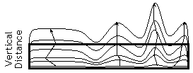
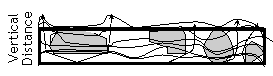
1. Beginning with the upwind strip, fire growth and minimum travel routes are computed. Concave segments along the fire arrival time contour are identified. These segments are concave in terms of the fire arrival time, which means that they start and end with a local maximum arrival time. This procedure assumes that the fire front will have a rippled time contour or “fingers” at the forward edge produced by varying spread rates that result from fuels, topography, or wind patterns. |
|
2. The algorithm targets fuel treatments to block these fingers since they are local zones of faster spread. For relatively uniform conditions, where little or no variation exists, the algorithm must be modified to place fuel treatments by some other rule. The rule used here within a given strip was a systematic and regular spacing, which produces the ripples at later time periods. |
|
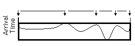
3. Within the strip, the minimum travel time path for each segment is identified and followed backwards in time and space to record intersections with areas where fire behavior differences exist between the two landscapes. A choice is made for the best place to start the fuel treatments for each segment. At present, the choice is based on criteria of having the earliest time where fuel treatments are possible but no earlier than the back-edge of the strip. Arrival times are reset to infinity for all nodes (on the entire landscape) having an arrival time later than the time at the starting location. |
|
4. The minimum travel-time algorithm is then re-run for the strip using the post-treatment landscape data (dark line contour to the left). This is done for the entire strip separately for each segment identified in #1 above since the time contour used as starting point for fuel treatments identified in step 3 is typically different for each segment. The new arrival time map is stored for each segment and represents the rate of fire growth assuming all fuel treatments have occurred. |
|
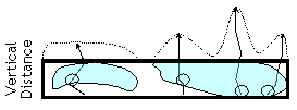
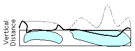
5. An iterative procedure identifies and marks the cells of the landscape as treated. A contagion algorithm is used to fill in a block of treated cells starting from the earliest arrival time contour and a later one that contains the maximum area treated within the specified constraint. The maximum area treated is found through iteration starting from points identified in step 3 and fire progression are added to broaden the difference between the starting- and ending-time contours produced on the treated landscape. This procedure continues incrementing time until the specified fraction of the landscape (strip) is treated. |