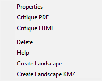
Right-clicking an analysis area item in the "Tree" pane displays this short cut menu. The Delete command is not available for the ♦ Entire Landscape (Default) analysis area and FlamMap will display a warning if you attempt to delete it.
A landscape area consists of the Landscape Grid Themes and any associated Runs. It can be the entire project landscape (♦ Entire Landscape (Default)) tree item, or a portion of the project (♦ New Analysis Area) tree item.
|
|
Right-clicking an analysis area item in the "Tree" pane displays this short cut menu. The Delete command is not available for the ♦ Entire Landscape (Default) analysis area and FlamMap will display a warning if you attempt to delete it. |
Selecting the Properties command from the shortcut menu displays the following read-only dialog with the UTM boundaries and other GIS information for the landscape.

Generates a report summarizing landscape characteristics with graphics. Critiques can be generated for the ♦ Entire Landscape (Default) or for any ♦ New Analysis Area.
This command will delete the selected ♦ New Analysis Area. This Delete command is not available for the ♦ Entire Landscape (Default) analysis area and FlamMap will display a warning if you attempt to delete it.
Analysis Areas (including ♦ Entire Landscape (Default)) can be saved in standard Landscape (.LCP) File or GeoTIFF (.TIF) format. This feature can be used to clip a smaller landscape area of interest from a larger landscape. Saving to GeoTIFF (.TIF) format requires the FlamMap Project contains valid projection information.
The command opens a "Select Destination File" dialog box allowing the user to navigate to the location they want to store the newly created file. The user must designate Save as Type as either .LCP or .TIF.
Analysis Areas (including ♦ Entire Landscape (Default)) can also be saved in .KMZ format for viewing in Google Earth. The command opens a "Save As" dialog box allowing the user to name the .KMZ file and navigate to the location they want to store the newly created file.
If this command is not available (greyed out) it is likely because valid projection information is not available for the ♦ Entire Landscape (Default).
Selecting the Help command will bring you to the Landscape Area heading above in this online help system.