
Spotting in FlamMap and FARSITE is only simulated from torching trees (Albini 1979) when passive and active crown fire are modeled. Independent crown fire is not modeled, see Crown Fire - technical documentation. Maximum spot distances of embers from burning slash piles (Albini 1981), and line surface fires (Albini 1983a, 1983b, Morris 1987) are calculated in BehavePlus, but are not present in FlamMap or FARSITE. As originally implemented in BEHAVE, the spotting component of FlamMap and FARSITE is intended to compute the maximum spotting distance from a given point on a fire front if torching occurs. It is not intended to simulate the numbers of embers, exact locations embers would land, or locations of resulting spot fires.
Spotting is achieved as a 4 step process. In the first step each of the 16 embers is assigned a random number (0.0 - 1.0) and evaluated against the Ember Spot Probability setting. For example if the Ember Spot Probability setting is 0.05, then any embers with a random number greater than 0.05 are removed from the spotting process. Interestingly, at any spotting vertex there can then be 0-16 embers lofted depending on the 16 random numbers. Zero or 16 will be rare but across the entire simulation the proportion of embers lofted will be very close to the Ember Spot Probability setting.
The second step determines the maximum lofting height of cylindrical embers of 16 size classes (1/16" to 1 inch) that originate at the top of a tree or group of trees (see diagram above). Some embers may be too heavy to be lofted by the given plume generated by the torching tree(s). The burning characteristics of a tree (flame height and duration) are determined by size and species of the trees (Albini 1979). The number of trees torching at once is linked to the Crown Fraction Burned and Canopy Cover. The numbers of trees torching in a group affects the flame height and duration important to lofting of embers (Albini 1979). The following rules below are assigned.
|
` |
Crown Fraction Burned |
||
|
Canopy Cover |
< 50% |
50% to 80% |
80% + |
|
<50% |
1 |
2 |
3 |
|
50% to 80% |
2 |
3 |
6 |
|
80%+ |
3 |
6 |
10 |
The third step begins after remaining embers from all portions of all fire fronts are lofted in a given time step. Each ember is iteratively descended until it is extinguished or contacts the ground. The iteration assumes that each ember falls at its terminal velocity determined by diameter and the time since it began falling. Using 50 ft. steps for vertical drop, the iteration accounts for change in the ground elevation, wind speed as a function of height above ground, and time of flight. Embers are assumed to follow the ambient wind direction. An ember will be extinguished if it is airborne longer than the burning duration determined by its size (Albini 1979). Above the canopy height, a logarithmic wind profile is assumed. This may overestimate spot distance if the terrain is not forest covered (Albini 1981). Below the canopy, the mid flame wind speed is assumed vertically constant.
The forth step involves ignition of spot fires, applying the Spot Delay, and checking for impact of the embers upon the landscape. Obviously any embers landing within existing fire perimeters are ignored. Through FARSITE version 4 all live embers landing on burnable fuel models ignited a new fire. However this consumed considerable processing time as the model "untangles the spaghetti" that is created from many spot fire growing near each other. Also, most FARSITE modeled spots are 'near distance' and appear to have little impact on the final modeled fire perimeter or fire behavior outputs; the surface fire simply overruns these spots. For the implementation of FARSITE in FlamMap version 6 two modifications were made to speed up processing time.
An area adjacent to the current simulated fire perimeter, a minimum spotting distance, can be set to prevent spot fires that would likely be overcome by the advancing perimeter. Also a background spotting grid is created to limit spot fires very close to each other. These two modifications are shown in the following diagram.
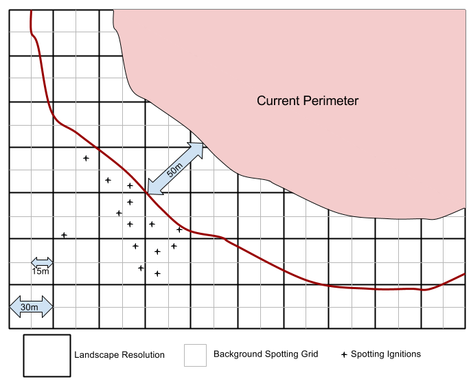
In the above example, on a 30 meter landscape with a 50 meter minimum spotting distance, no spots occur in the first 50 meters from the current perimeter. Any viable embers that land beyond 50 meters can produce spot fires with the limitation that only the first spot ignition in each Background Spotting Grid cell is allowed to burn.
Fire behavior is calculated for each landscape node, nodes are a fixed grid equal to the landscape or MTT spatial resolution. If a node experiences passive or active crownfire, sixteen (16) incrementally-sized embers are lofted and followed to determine the maximum spotting distance and direction. Crown Fraction Burned and Canopy Cover are used to determine the number of torching trees (1-10) used to determine firebrand lofting height. Maximum spotting distance & azimuth are calculated using canopy cover, crown fraction burned, elevation, and wind information, including gridded wind if available. The Maximum Spot themes are created from this information.
For Runs utilizing the MTT fire growth model (MTT and TOM Runs) the Maximum Spot themes are created as described above. As each node in MTT burns it checks for Maximum Spot data for that location. If it encounters Maximum Spot data at a node, MTT then draws a random number (0.0 – 1.0). If the random number is greater-than the user entered spotting probability, the location is discarded and no spotting occurs from that node during that time frame. Otherwise, MTT then calculates a flight distance for the ember as follows:
distance = –log( r ) * Maximum Spot Distance / 5
where r is a random number (0.0 – 1.0). MTT then calculates the landing node for the ember using the calculated distance and the direction from the Maximum Spot Direction theme. If the node is non-burnable or already burning, the ember is discarded and spotting does not occur from the source node. Otherwise the node is set as an ignition with initial start time of the current simulation time.
The spotting distance used to determine the landing node for an ember will never be greater than the Maximum Spot Distance value at the source node. More embers will be lofted at finer landscape resolutions. Faster rate of spread (ROS) will encounter more nodes, but the absolute number of nodes is static. Because only one ember per node is used there is less chance that an ember will travel the maximum distance compared to Near Term Fire Behavior (NTFB) in WFDSS and in FARSITE.
Spotting only occurs when passive or active crown fire is modeled. Finney (2004) or Scott & Reinhardt (2001) crown fire methods are options set by the user. Each method calculates Crown Fraction Burned (CFB) differently (Scott 2006).
At present, all embers burning at impact ignite spot fires. The probability of ignition (Bradshaw et al. 1984) is not utilized.
A Spot Probability (MTT) or Ember Spot Probability (FARSITE) of zero will prevent any spot fires from occurring, effectively disabling the spotting feature.