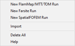
Right-clicking the ♦Runs item in the "Tree" pane brings up this shortcut menu.
A FlamMap, Minimum Travel Time, or Treatment Optimization Model run is initiated by right-clicking the ♦Runs item in the "Tree" pane and selecting the New FlamMap/MTT/TOM Run command from the short cut menu. Or select the Analysis Area > New FlamMap/MTT/TOM Run command from the menu bar. The "Run:" dialog opens showing the Inputs tab. You should first name your run to avoid confusion with several ![]() New Run items in your "Tree" pane.
New Run items in your "Tree" pane.
Run information is saved when you close the "Run:" dialog box by clicking the OK button, regardless of the run status. For example if your Inputs tab is incomplete, just the information you have entered is saved. If you have a completed run with output grids, then those are saved with the project.
A FARSITE run is initiated by right-clicking the ♦Runs item in the "Tree" pane and selecting the New Farsite Run command from the short cut menu. Or select the Analysis Area > New Farsite Run command from the menu bar. The "Farsite Run:" dialog opens showing the Weather Inputs tab.
SpatialFOFEM provides spatial fire effects information for smoke emissions, carbon loading, and fuel consumption identical to those from the non-spatial First Order Fire Effects Model (FOFEM).
Selecting the New SpatialFOFEM Run command from the short cut menu opens the "SpatialFOFEM Run" dialog with the SpatialFOFEM Inputs tab displayed.
Run inputs can be imported from other FlamMap Projects or the Wildland Fire Decision Support System (WFDSS).
FlamMap and Farsite runs are imported with a Run Log output item saved from a previously completed run. WFDSS Basic, Short Term, and Near Term analyses are imported using the Analysis Input file downloaded from the Results tab of a WFDSS analysis.
Selecting the Import command open a standard Windows Open dialog where you navigate and select the file to import.
NOTE: Importing Run Logs and WFDSS Input files have some interesting quirks. See the Limitations section of the Run Logs topic for more details. Sharing or moving FlamMap or Farsite runs is easily accomplished with the File > Save and Archive command, so consider this option instead of a Run Log.
Selecting the Delete All command from the ♦ Runs shortcut menu will remove all runs from the analysis area.
NOTE: To delete just an individual run select the Delete command from shortcut menu shown below.
The Help command will bring you to this page in the online help system.
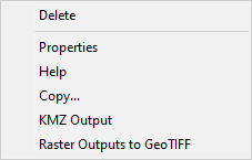 |
Right-clicking any of the individual run tree items, such as |
Selecting the Delete command from an individual run shortcut menu will remove just that individual run.
The run Properties command is only available from the shortcut menu of an individual run item, which have the ![]() icon. You can also double-click individual run item.
icon. You can also double-click individual run item.
This command opens the "Run:" or "Farsite Run" dialog box where you can modify the run and generate new outputs.
The Help command will bring you to this page in the online help system.
The Copy... command create a copy of the run, but not the outputs, adds the prefix "Copy of" to the run name and opens the "Run:" dialog box for the new copy.
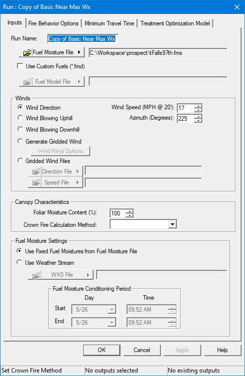
You can rename the new run (recommended), modify the run in any of the tabs and generate new outputs.
The KMZ Output and Raster Outputs to GeoTIFF shortcut commands can save an entire run's output in one file. This is a very convenient single file format for sharing run results.